Salgado da Figueira da Foz
Name: Salgado da Figueira da Foz
Location
The Salgado da Figueira da Foz (Latitude: 40 ° 8 '48''Longitude: 8 º 51' 24'') contains the distal sector of the estuary of the Mondego river as central geographical unit, where the Island of Morraceira stands out. It encompasses the parishes of St. Peter Vila Verde and Lavos..
Description
The Island of Morraceira (from morraça - cordgrass) is located at the mouth of the Rio Mondego. This estuary has an area of 3.4 km2, an average depth of about 2 meters and a typical depth of about 4 meters, in the subtidal areas – out of tidal influence. In this area the river divides into two, surrounding the island with silt. These two arms (north and south) come together again at about 1 km from the mouth, opposite the city of Figueira da Foz This deposition of alluvial sediments (sand and mud) in the downstream zone of the estuary has led to the formation of the Morraceira island, which is about 1,482 acres, separating the two river arms. This island includes appreciable extensions of marshes, reeds, rushes, salt works and aquaculture or fish farms.
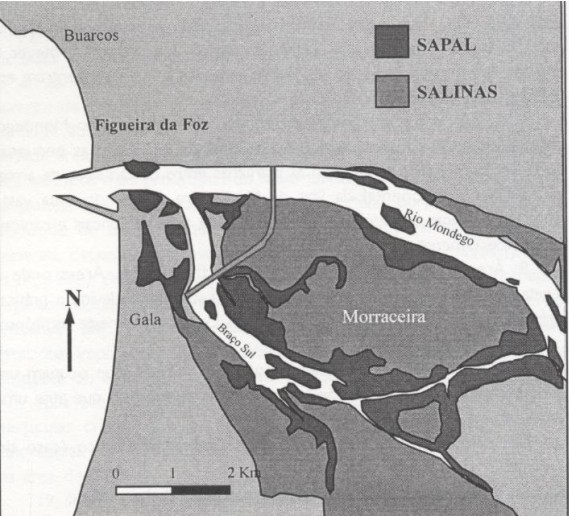
Fig. 1 – Sketch of the distribution of areas of salt marsh and salt pans of the Mondego estuary, according to the distribution chart of biotypes by Marques et al. 1984.
The exploitation of salt in the Mondego estuary was one of the main economic activities of Figueira da Foz. The type of salt pans and production techniques practiced in this salt works has specificities that cannot be seen in any other salt-producing region of Portugal or Europe. Its technical craft, which is extremely careful and well adapted to the environment, has survived to the present day.
In the middle of the 20th century, the salt works of Figueira da Foz had a total of 229 salt pans, distributed on the Ilha da Morraceira (141 salt pans on a 1,282 acres surface), the left bank of the South Arm and Ínsua D. José (71 salt pans occupying a surface of 615 acres) and on the right bank of the North Arm (17 salt pans occupying about 74 acres). It is to be noted that 212 acres are navigable at all tides, 155 in half tide and 148 only in spring tides, there are still 20 salt pans that can be served only by land.
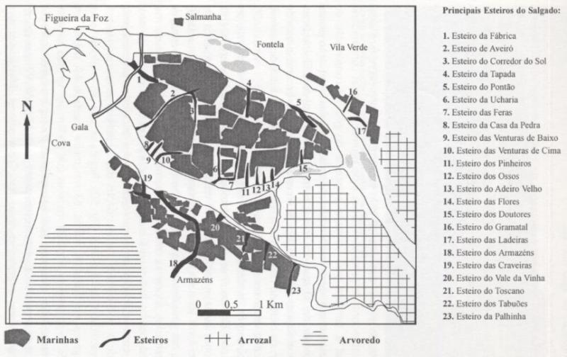
Fig. 2 – Location of salt works (including nurseries) and major estuaries, taking into account the land register of 1954 (based on data adapted from L. Lopes, 1955).
There is a change from circumstances in which salt represented the backbone of the activities of the estuary, directly involving hundreds of people - in the mid 20th century – there were 300 owners of and 1,300 workers, of which 500 were men (S . Dionisio, 1945) – to present conditions in which there are an estimated 40 to 50 salt pans functioning poorly.
The salt works represent, in themselves, an extraordinary cultural legacy, beyond the value of the product that is extracted. Its internal organization, functioning and the specific work carried out by the marnoto (salt worker) are well worth further investigation.
The sustainability of estuarine wetland has to include the maintenance of the salt-producing activities in traditional salt pans which, among many other positive functions, provide privileged locations in terms of landscape and biodiversity, with no negative environmental impact and even providing positive contributions to environmental quality. In this respect, we highlight the role of the exchange of sea water in the protected reservoirs, giving rise to large numbers of species of benthic macrofauna that are essential for the survival of many other species and are important resources for the local community.
Occupied areas: Active Salt works
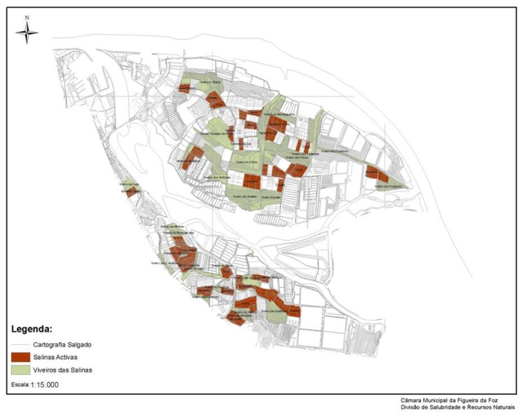
Fig. 3– The territory of the salt works of Figueira da Foz - Salinas Activas (Active salt pans) (2003).
The activ saltworks, and the second survey of 2003, constitute a total area of 588 acres.
Filling a percentage of the current total surface (3597 acres) with a value of 16.3%.
- No. of salt pans = 52 + 22
Areas of abandonment: inactive salt pans of the salt works
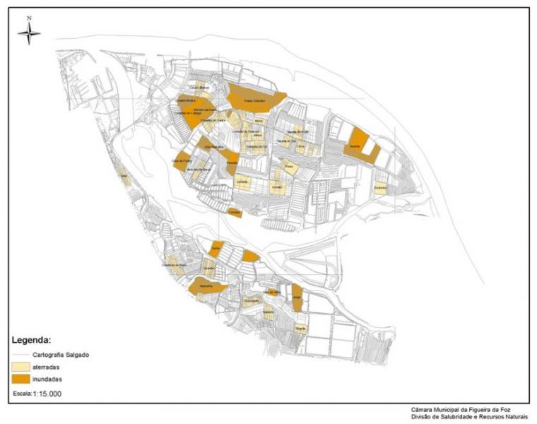
Fig. 4– The territory of the salt works: Inactive salt pans (2003).
Inactive salt pans correspond to 387 acres, and there are 172 acres of land filled salt pans and 214 acres of flooded salt pans.
Filling a percentage of the total current surface (3597 acres), with a value of 10.3%.
- No. of salt pans = 44
- No. of land filled salt pans =29
- No. of flooded salt pans =15
Areas with other uses: aquaculture
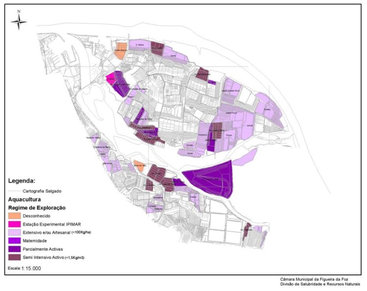
Fig. 5– The territory of the salt works: occupied by aquaculture (2003).
Aquaculture represents an area of 840 acres and is divided into various regimes:
1 - Semi - Intensive Active (<1.5 kg/m3) = 126 acres,
2 - Partially Active or Inactive = 197 acres
3 - Extensive and / or Artisanal (<100kg/ha) = 481 acres
4 - Unknown = 9.6 ha
5 + 6 - Experimental Station of IPIMAR + Motherhood = 11 acres
Filling a percentage of the total current surface (3597 acres), with a value of 23.4%.
- Total No. = 49
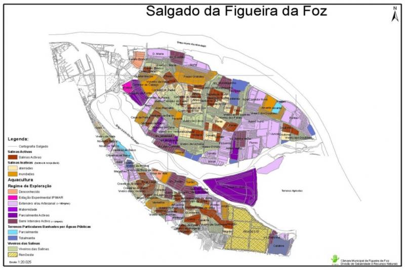
Fig. 6– The Salt works territory: data analysis.

